
In the second blog in our series about the RPA mapping process and how to carry out mapping-related tasks ahead of scheme applications, this blog will guide you through using a map to clearly identify a division or split of a land parcel.
It's vital that you ensure your land details are up-to-date before you apply for Countryside Stewardship Mid Tier. This also applies to the Sustainable Farming Incentive (SFI). Land details shown on your digital maps in the Rural Payments service are used for several of the land-based schemes and that’s why it’s important to keep your mapping up to date.
You can use the RPA RLE1 form to make changes to your digital maps, register new land and transfer land.
How to divide a parcel into three using new fences
Providing accurate length measurements will help us map the divisions correctly.
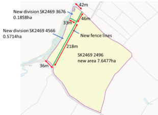
- You should annotate length measurements and areas, where you have them, and then indicate if any of the measurements/areas are estimated.
- Clearly identify the new dividing boundaries and confirm the type of boundary used.
- Identify each new parcel with a parcel identification number and estimated area.
- This map has estimated areas provided in red that are not achievable when following the supplied measurements. It is likely that this will be queried by RPA and could cause a delay.
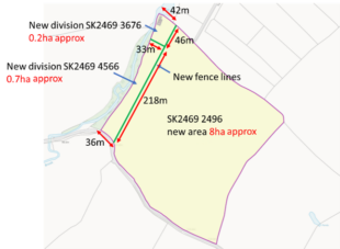
- Identify estimated figures on the map using the term ‘approx’. RPA’s mapping digitisers will know that the length measurements are more reliable to follow in this scenario.
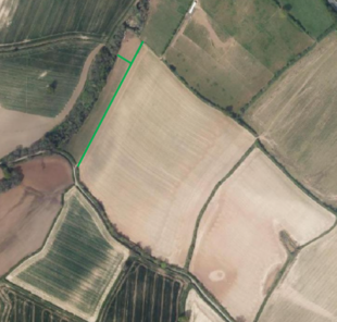
- This requested division has been supported by a recent update to the RPA aerial photography intelligence. The RPA will utilise the latest intelligence in the form of aerial photography, ordnance survey data or remote sensing to help aid the accuracy of our mapping.
How you can help ensure timely and accurate updates
- Provide accurate areas and measurements. If an area or measurement is estimated please note this on the map, using the term ‘approx’.
- RPA will query amendments that affect third parties and this may delay the mapping of your land.
- Make sure any dividing boundaries are supported by permanent obstructing boundaries such as a fence, hedge or wall.
- Ownership boundaries which are not supported by a permanent boundary should not be used to divide land.
- Crop splits should not be used to divide land.
It's vital that you ensure your land details are up-to-date before you apply for Countryside Stewardship Mid Tier. This also applies to the Sustainable Farming Incentive (SFI). Land details shown on your digital maps in the Rural Payments service are used for several of the land-based schemes and that’s why it’s important to keep your mapping up to date.
Use the RPA RLE1 form to make changes to your digital maps, register new land and transfer land. For guidance on how to fill in an RLE1 form, follow the steps in this blog post.
To stay up to date with the latest information and updates from RPA, sign up to our blog and follow us on social media on the following accounts:
- Follow us on Twitter @ruralpay
- Sign up for our blog at blog.gov.uk
- Facebook: facebook.com/RuralPaymentsAgency
- YouTube: Rural Payments Agency
By following and subscribing to our social channels and blog, you’ll be able to see the latest updates about important information. We also share top tips and announcements.
You can also listen to The RPA Podcast which we have launched to help farmers, landowners and rural communities keep up to date with the latest news from RPA.
7 comments
Comment by Sarah Robinson posted on
Is there a minimum change which requires an RLE1 form? For example if a fence in being moved in order to enable a new hedge or a streamside corridor to be created, is there a distance under which an RLE change is not deemed necessary?
Comment by RPA Editor posted on
Thank you for getting in touch. If a physical change is resulting in a change in area for your land parcel then this should be reflected in your digital maps. There isn’t a minimum change threshold.
Comment by James Griffiths posted on
Do you have a similar guidance for combining 2 parcels please?
Comment by RPA Editor posted on
Hi James, if you are merging two parcels because the permanent boundary has been removed you need to submit on an RLE1 form with a map showing which boundary has been removed. However you cannot merge two parcels if there is still a permanent boundary in place.
Comment by Gillian LANE posted on
Is there a grant available for fencing off a stream area and if so how much,
also what scheme would suit that area which would be both sides, thank
you.
P,S It is quite some distance at the bottom of my land.?
Comment by Zoë Horlock posted on
If I divide a parcel can I put a temporary fence as would like to apply for a capital grant to install permanent sheep fencing?
Comment by RPA Editor posted on
Hi Zoë, as long as you replace it with a permanent fence as soon as possible that would be fine.