This is the first blog in a series about the RPA mapping process and how to carry out mapping-related tasks ahead of scheme applications. This blog will show you how to fill in the RLE1 form - electronically or on paper.
It's vital that you ensure your land details are up-to-date before you apply for Countryside Stewardship Mid Tier. This also applies to the Sustainable Farming Incentive (SFI). Land details shown on your digital maps in the Rural Payments service are used for several of the land-based schemes and that’s why it’s important to keep your mapping up to date.
The RPA RLE1 form enables you to make changes to your digital maps, register new land and transfer land.

Fill in your Single Business Identifier (SBI) and name of beneficiary or business name
If you want to use land to claim BPS at the same time as an agri-environment or woodland scheme applicant wants to use it, then it needs to remain linked to your SBI. To do this, write ‘Dual use – maintain link to existing SBI’ on the front page of the form. Make sure you enter ‘(Keep link)’ after the business name in section B2. If you’re submitting your RLE1 by email, put ‘RLE1 Land Change’ and your SBI in the email subject heading.
You no longer have to fill in CPH numbers on the RLE1. However, there are Defra rules on the allocation of CPHs and British Cattle Movement Service (BCMS) links to land parcels for animal movements and disease control purposes.
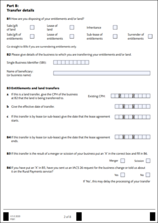
Fill in Part B if you want to transfer BPS entitlements/land or remove land.
You don’t need to fill in Part B and Part C if you only want to register new fields, make changes to permanent non-agricultural areas or features, make changes to your land covers or make permanent boundary changes to your land parcels. Fill in Part D to make land amendments.
Existing Field Data
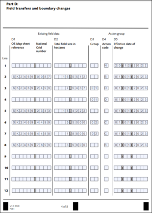
 Form section: D1- OS map sheet reference and national grid number.
Fill in the OS map sheet reference and the National Grid number of the land parcel for which you’re making the amendment. If registering a new parcel, D1 should be kept blank. The parcel ID will be entered into D6 on page 5.
Form section: D2 - Total field size in hectares.
Fill in the land parcel area, to four decimal places. If registering a new parcel, D2 should be kept blank. The estimated area of your new parcel will be entered into D7 on page 5.
Form section: D3 - Group.
Use the group column to identify groups of parcels being amended together. Give your own two-digit number, for example, 01, 02 or 03, to act as a group code. In the example below, the two parcels that are being combined together as one parcel have been grouped into number 05.
Form section: D4 - Action code.
Fill in the action code ‘N’ for a new parcel.
Fill in the action code ‘B’ for a boundary change.
Fill in the action code ‘D’ for a dividing parcels.
Fill in the action code ‘I’ for a feature (land cover amendment).
Fill in the action code ‘C’ for combining parcels.
Fill in the action code ‘B’ for a boundary feature change (hedge).
Form section: D5 - Effective date of change.
Fill in the effective date of change, which is the date when you changed (or will change) the land parcel.
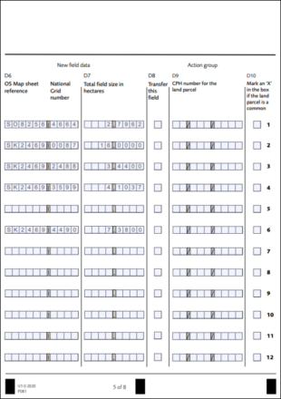
Form section: D6 - New Field Data
((c) Crown Copyright and database rights 2023. Ordnance Survey 100022861.)
New parcel - Fill in the OS map sheet reference and the National Grid (NG) number of the land parcel(s) you are adding.
Boundary change - Fill in the OS map sheet reference and NG number after the change. This may be the same as the old parcel ID, but you still need to complete this column. When RPA updates the land parcel in your digital map, the land parcel number may not be the same as your estimated number.
Division - Fill in the estimated new OS map sheet references and NG numbers of the land parcels once they have been divided. When RPA updates the land parcel in your digital map, the land parcel reference number may not be the same as your estimated numbers.
Land cover amendment - D6, D7, D8 and D9 should remain blank for this mapping request.
Combination - Fill in the estimated new OS map sheet reference and NG number of the land parcel once they are merged. When RPA updates the land parcel in your digital map, the land parcel reference number may not be the same as your estimated number.
Boundary feature change (hedge) - D6, D7, D8 & D9 should remain blank for this mapping request.
Form section: D7 – Total field size in hectares.
Fill in the total land parcel area in hectares, to four decimal places – your best estimate. When RPA updates the land parcel in your digital map, the land parcel area may not be the same as your estimated area.
Form section: D8 – Transfer this field.
This column is for removing or transferring land parcel(s). If you’re not removing or transferring land, this column should remain blank.
Form section: D9 – CPH for the land parcel.
You no longer need to fill in CPH numbers, but it may be helpful.
Part E - Supporting documents
If you’re sending supporting documents with your RLE1, we need to know what you’ve included. Please ignore Part E if you’re not sending supporting documents.
Form section: E1 - Fill in the number of each type of supporting documents that you’re sending to us. The following maps are acceptable supporting documents:
- RPA maps
- Natural England Farm Environment Record map
- OS or professionally drawn maps
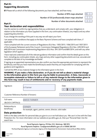
Part F - Your declaration and responsibilities
Please read the declaration and responsibilities carefully before signing the form. If you’re sending us a paper RLE1, remember to:
- Use capital letters
- Sign and date the form
- Make sure you (or your agent if they complete the form for you) have the correct permission level to sign and submit the form. You can check your permission level in the Rural Payments Service or read about correct permissions levels in the Permissions table.
- Complete in your own name, not the name of the business
- Give your customer reference number (CRN) if you have one, or explain your relationship to the beneficiary
- If you’re sending us an electronically completed form, fill in the signature box electronically by typing your name
- You need to send electronic RLE1s from an email address registered in the Rural Payments service
- Please do not cross out or deface the declaration and responsibilities in Part F as we will have to reject the form.
4 comments
Comment by Emma Greig posted on
Helpful article but completing an RLE1 form is only any good if the RLE1 form is then processed. As an Agent I am regularly submitting forms on behalf of clients and have found RLE1 forms submitted March to May 2022 have not been processed and have only been processed since resubmission in March to May 2023.
Comment by RPA Editor posted on
Thank you for getting in touch. We ask that if this happens could you please contact our helpline on 03000 200 301 and a member of our team will be able to look into this for you.
Comment by Peter Tierney posted on
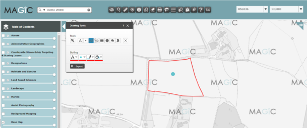
I Don't think you say where to get Magic to get field data,
Comment by RPA Editor posted on
Good morning. Thank you for getting in touch, you can access Magic on the following link: https://magic.defra.gov.uk/home.htm.